Back in April we featured a video a video on Bronx born and raised Dr Melissa Freeman and now Good Morning America has a longer feature on this fascinating woman who at 92 years is still a practicing doctor!
According to the interview the Williamsbridge native sees hundreds of patients a year treating individuals with opioid addiction and rides the subway at least twice a week.
During the second quarter of 2018, more than 9 million square feet of construction was completed in New York City resulting in the highest level this decade and even besting pre-recession levels according to an analysis conducted by The Real Deal.
And The Bronx just shattered its own record.
The Real Deal reports that The Bronx completed over 1 million square feet of new construction during Q2 as developments received their first temporary Certificates of Occupancy for the first time.
Just take a look around the borough and you’ll notice a slew of residents moving into new developments particularly in the South Bronx like Mott Haven’s first luxury new construction condo, The Joinery and its neighbor across the street 255 E 138th Street, an affordable housing development known as The Graham.
With all these new construction developments coming on line quarter after quarter year after year, how will our crumbling infrastructure handle it all?
Our subways are packed and failing so how are these new residents going to get to work?
Whether documented or undocumented one thing is clear: Immigrants have helped shape the economic boom The Bronx is currently experiencing.
According to Crain’s, unemployment is the lowest since 1990 when statistics began being tracked and The Bronx leads the city with the highest average salary in the health care industry in New York City at $61,100.
When compared to Brooklyn and Queens, The Bronx has had the highest population growth since 1980 at 26% and is now the fastest growing county in New York State.
It also leads gains in business sales since 2007 at 60% growth but still has the highest poverty rate at 28.4% and the lowest median income at $37,500 of the five boroughs.
The bottom line is similar in all three boroughs: Large population increases fueled by immigration since 1990 have revitalized them and in the past decade have boosted the number of businesses, their sales and the job count. Unemployment also has been reduced to the lowest rate since the government began tracking it in 1990.
The Bronx remains the weakest, with the highest unemployment rate and by far the lowest median income. One bright spot is its solid average private-sector wages, better than Brooklyn’s and Staten Island’s and not much behind those in Queens. Health care is the largest employer in the Bronx, and the big institutions that dominate it pay well. The average Bronx health care salary, $61,100, tops the citywide average for that category.
While The Bronx is booming, it’s more important now than ever to ensure that no one gets left out or pushed out as gentrification continues to creep in.
The very people that helped reshape our borough are the ones most at risk for displacement.
Akua Afriyie, a woman in her 70s in living in The Bronx, isn’t your ordinary senior citizen.
Instead of simply just enjoying her retirement, she’s hard at work creating her own fashion line according to this video from News12 The Bronx.
She tells News12 that in order to make ends meet she had to set aside her dream to work in the fashion industry but now she wants to inspire other seniors and show them that age shouldn’t be a barrier.
Councilman Ritchie Torres is calling for an investigation into Montefiore Hospital as staff and nurses are calling out the institution’s terrible practices.
According to staff, Montefiore places patients insured by Medicaid, essentially the poorest of the poor and most vulnerable, into crowded hallways awaiting treatment.
This is an extremely disturbing account on The Bronx’s largest employer as the hospital is entrenched in every corner of our borough.
Sickly patients packed into rooms like sardines. Psych patients attacking harried hospital staffers. Nurses forced to treat up to 12 critically ill children at the same time.
The Montefiore Medical Center emergency units are often dangerously overcrowded and unruly — imperiling the lives of the ailing Bronx residents who flock there, nurses told the Daily News.
“It looks like a refugee camp in a war zone,” said nurse Benny Matthew, 41, who works at the main Moses Campus’ ER in the Norwood section of the Bronx. “I’m from India. Even if I go to an emergency room in my country, I don’t see things like this.”
Montefiore Medical Center is an “entrenched, arrogant bureaucracy” that offers “substandard” emergency care to Bronx patients, a city lawmaker railed Saturday as he demanded a probe into the long wait times and overcrowding that plague the sprawling hospital network.
Montefiore — which operates three emergency rooms in the borough — routinely subjects patients to “interminable” waits, only to treat them in crowded hallways due to a chronic shortage of beds, Councilman Ritchie Torres told The Post on Saturday.
It’s time they are held accountable, he said.
“Why are we relegating vulnerable patients to cramped and crowded hallways, where the risk of infection is high and there’s no privacy for interviews and physical exams and toileting — and there’s constant light and noise that prevents you from sleeping?” asked Torres.
Montefiore’s high-volume Bronx outposts are the largest recipient of city Medicaid dollars, Torres said.
Not only are they the largest employer in our borough but they are also the largest recipient of Medicaid funds in The Bronx.
This is the problem with hospitals and the health care industry when it’s about dollars and profits and not patient-centered care.
The spacecraft carrying humans beyond the Earth and to Mars and the stars might might be designed by someone in The Bronx thanks to a grant from NASA to Bronx Community College.
BCC will receive over $300,000 to develop new STEM courses that will allow students to participate in NASA-related projects announced Congressman José E. Serrano.
See the full press release below:
Congressman Serrano Announces $300,000 NASA Grant for Bronx Community College’s New STEM Courses
Aug 2, 2018
Press Release
Washington, DC – Congressman José E. Serrano, Ranking Member of the Commerce, Justice and Science (CJS) Appropriations Subcommittee, today announced that Bronx Community College in the Bronx will receive $317,098 in funding to develop and offer new science, technology, engineering and mathematics (STEM) courses through the NASA’s Minority University Research and Education Project (MUREP). These courses provide minority and low-income students with the opportunity to participate in NASA-related STEM workshops. The goal of the project is to help prepare, train, and develop NASA’s future workforce.
“The STEM fields will only continue growing in importance in coming years. By engaging minority serving institutions like Bronx Community College, NASA is helping ensure that every child has access to the education and training they need to pursue careers in the STEM fields and at NASA itself regardless of social or economic background. This funding is an investment in our future generations, in NASA’s future capabilities, and in our future scientific competitiveness. As the Ranking Democrat on the appropriations subcommittee that funds NASA, I have prioritized efforts to expand opportunities for our most talented individuals from all communities to enter the STEM fields,” said Congressman Serrano.
Bronx Community College was one of five education institutions selected for this grant award. More information on their initiative from NASA’s grant award notification is below:
Bronx Community College, New York The courses proposed by this school are geared toward enrolling minority and low-income students to participate in a series of hands-on and field-based workshops. The workshops will focus on inquiry-based geospatial technology and STEM activities developed by using NASA’s online data repositories and state-of-the-art equipment available through partner institutions. The participants will learn to analyze Earth observation data, develop automated feature extraction tools, and perform image analysis and classification.
Posted 12 minutes ago
The National Weather Service in Upton NY has issued a
* Tornado Warning for…
Queens County in southeastern New York…
Bronx County in southeastern New York…
Northern Nassau County in southeastern New York…
* Until 1045 PM EDT.
* At 1018 PM EDT, a severe thunderstorm capable of producing a
tornado was located over Whitestone, or over Flushing, moving east
at 20 mph.
HAZARD…Tornado.
SOURCE…Radar indicated rotation.
IMPACT…Flying debris will be dangerous to those caught without
shelter. Mobile homes will be damaged or destroyed.
Damage to roofs, windows, and vehicles will occur. Tree
damage is likely.
* This dangerous storm will be near…
Bayside around 1025 PM EDT.
Great Neck and City Island around 1030 PM EDT.
Garden City and Port Washington around 1040 PM EDT.
Glen Cove and Mineola around 1045 PM EDT.
TORNADO…RADAR INDICATED
HAIL…0.00IN
Recommended actions
TAKE COVER NOW! Move to a basement or an interior room on the lowest
floor of a sturdy building. Avoid windows. If you are outdoors or in
a vehicle, move to the closest substantial shelter and protect
yourself from flying debris.
So while the South Bronx might be hot in terms of real estate buzz, it’s not the home of the most expensive listings in The Bronx for residential properties.
So where in The Bronx are the most expensive properties for sale?
From single families to coops and condos, Riverdale is still the undisputed leader in the real estate world of The Bronx when it comes to this category.
In fact, every single listing listing in the top ten category is in the greater Riverdale neighborhood which includes swanky Fieldston as well as Spuyten Duyvil.
Here they are from “cheapest” to most expensive:
10. 5250 Independence Avenue – Asking $3,850,000
This slideshow requires JavaScript.
This is really such an average looking home on the inside (maybe it’s the decor) but with 7 bedrooms and 7.5 bathrooms it’s anything but average. Oh did we mention that it comes with a pool AND a pool house? [see more]
9. 645 West 252nd Street – Asking $3,850,000
This slideshow requires JavaScript.
This 4,800 square foot center hall colonial was built in 1930 and is listed as a 5 bedroom home with 4.5 baths and a swimming pool. It’s one of the nicer homes on our list. [see more]
8. 640 West 237th Street, #20B – Asking $3,950,000
This slideshow requires JavaScript.
This is the only condo apartment that actually made the top ten list.
At $3,950,000, 640 West 237th Street #20B in Riverdale is the most expensive condo on the market in The Bronx. The massive 2,755 square foot apartment has four bedrooms and four and a half bathrooms with stunning views of the Hudson River and Jersey Palisades.
The unit has access to tons of amenities like a rooftop with its own telescope and even a catering kitchen.
Of note is that this unit is located in the infamous Solaria Condominium where in 2009 over 50 units were sold at 45% off because the developer couldn’t sell them. This is perhaps the biggest failure in condo history in The Bronx. [see more]
7. 4611 Arlington Avenue – Asking $3,975,000
This slideshow requires JavaScript.
Not much to go by on this one as this is one sparse listing but it’s a 7 bedroom home built in 1899 (apparently recently updated or at least rather judging by the only interior picture) and has 5.5 bathrooms. The home also features 3 fireplaces. [see more]
6. 404 West 246th Street – Asking $3,995,000
This slideshow requires JavaScript.
This home has been on the market for almost two years and has dropped over $500k from its original asking price of $4.5 million back in 2016. It’s not uncommon for such homes to be on the market for so long in the area either. This 4,820 square foot home has 16 rooms, 6 bedrooms and five full bathrooms with two half-baths. It also has almost half an acre of land on its over-sized lot which is typical of Fieldston and uncommon in most of land-starved NYC. [see more]
Here’s a bargain deal: Two houses for the price of one. This sale is for two separate lots with two separate houses with a 5,000+ square foot guest house (4506 Delafield) with an indoor pool, four bedrooms and four bathrooms. The main house at 4485 Fieldston Road was built in 1930 and is much smaller at just 3,948 square feet. Doesn’t appear that they’re being sold separately. [see more]
4. 4925 Arlington Avenue – Asking $4,850,000
This slideshow requires JavaScript.
This one’s another bargain as you get three in one with a main house with 7 bedrooms and 7.5 baths, a second building with a gym and a third building with an office and a studio apartment. [see more]
3. 4730 Fieldston Road – Asking $6,650,000
This slideshow requires JavaScript.
This one is a special gem and a massive 10,000 square foot mansion on 1.3 acres of land across two lots. Try finding lot sizes that big in New York City outside of Fieldston and you’ll be hard pressed. This 20 room home has 10 bedrooms and 7 bathrooms (and 4 powder rooms). Bring your racket as the property also has its own badminton court. [see more]
2. 5275 Arlington Avenue – Asking $6,999,000
This whopper of a home has been on the market for over a year and has seen a price chop of just over $1 million bucks. The estate is a 15,000 square foot mansion on almost 2 acres of land with 24 rooms, 11 bedrooms, 11 bathrooms and is owned by the Republic of Kenya. [see more]
…and the most expensive house for sale in The Bronx is:
1. 4490 Fieldston Road – Asking $7,395,000
This slideshow requires JavaScript.
4490 Fieldston Road is for sale for a mere $7,395,000 and was listed a little over a month ago. What could possibly warrant such an asking price you ask?
Well the home itself is a modest 9 room “guest house”and built in 1930 with 4 bedrooms and 3.5 baths set on almost three full acres. And that’s where the hefty price tag comes in because you can build two quite massive mansions on the lots. You can purchase the vacant land by itself for $5.5 million but the house is not available by itself. It’s either all or just the vacant land.
A house this size on 3 acres in NYC is unheard of and perhaps might just be the ONLY home in NYC with that much land. [see more]
Hey…while we can’t afford any of these homes, we can dream, no? Which one is your favorite?
The following was originally published over at Hidden Waters Blog, a companion blog to the amazing Hidden Waters of NYC book by Sergey Kadinsky, and reprinted with permission.
It’s a fascinating look into our borough’s past and a search for the Kingsbridge neighborhood’s namesake: The King’s Bridge.
What do you know about this part of our borough’s history?
In search of the historic King’s Bridge on Bronx-Manhattan border
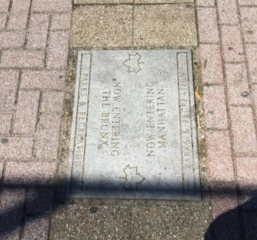
The oldest active bridge in New York City isn’t Brooklyn Bridge. It is the Roman-inspired High Bridge that connects western Bronx to the Washington Heights neighborhood of Manhattan. Further north there was a much older bridge that connected Manhattan to the mainland. King’s Bridge crossed over Spuyten Duyvil Creek that passed by the northern tip of Manhattan.
In the above 1906 photo of King’s Bridge, the crossing appears virtually unchanged from its appearance in 1766 when it opened as part of Albany Post Road. The creek was buried and rerouted in 1914, but are there any traces remaining of the city’s first bridge?
Where it Was
On the 1887 Edsall historical survey of this area, I highlighted the present path of Spuyten Duyvil Creek and circled King’s Bridge in orange. The knob of land between the highlight and the bridge is Marble Hill. To its east in red is Albany Crescent, a remnant of the old Albany Post Road. I also noted School Brook and Bronx River, which I’ve written about in prior posts.
This map is the Bronx equivalent of J. H. Innes’ 1908 Queens maps, which attempt to recreate the landscape at it appeared when the Natives were pushed out and the earliest European landowners staked their claims. The Native name for Spuyten Duyvil appears as Shorach Kappock, with 1645 as the year of “acquisition.” The Kingsbridge neighborhood appears as Paparinamin. The largest property on the map is the Manor of Fordham, which remains on the map as a neighborhood and street name.
The old bridge dates to 1693, constructed by Frederick Philipse at a spot known to Natives as the Wading Place, the narrowest point on the creek between Manhattan and the mainland. As Lord of Philipse Manor, he ruled over a vast property that stretched along the Hudson from Spuyten Duyvil Creek to the Croton River, with slave labor working on its farms, gristmills, and docks. The bridge’s name was given out of loyalty to the king and the toll exemption given to British military personnel. As the family was loyalist, the property was confiscated and subdivided during the American Revolution. By then, the competing toll-free Dyckman Bridge on 225th Street had siphoned most of the traffic from King’s Bridge.
Straightening Spuyten Duyvil
As early as 1817 when the Erie Canal was under construction upstate there were plans to straighten Spuyten Duyvil Creek. That year a narrow ditch was carved in the lowland separating Marble Hill from Inwood. But at only 4 feet in depth, it could not transport anything larger than a small boat. On the 1892 map above, the planned shortcut is labeled as “Government Cut in Progress.” The three highlighted bridges across Spuyten Duyvil Creek are King’s Bridge, the new Broadway bridge, and Dyckman’s Bridge.
That year engineer Louis A. Risse published a survey of the shortcut canal and Spuyten Duyvil Creek along with a grid of streets that would gradually cover the landscape. Annexed by New York City in 1873, the streets of western Bronx were an extension of the Manhattan grid, interrupted in many places by topographical obstacles. The rail line curving around the creek is the Hudson Line while the one running straight is the Putnam Line, which was abandoned in 1980. highlighted is Tibbett Brook, which was covered in the early 1900s. Tibbett Avenue runs atop the former waterway. Risse is a familiar name in Bronx cartography, having laid out the route of Grand Concourse.
Last Photos at King’s Bridge
From the Municipal Archives collection, city photographer Eugene de Salignac visited King’s Bridge on October 21, 1913 to document progress on the filling of the creek. The bridge is show running across land. Its wooden planks have been removed with paving stones to arrive by the end of the day. In the background a “for sale” sign on Dyckman Estate. After more than two centuries in the neighborhood, the family’s sizable property was shrinking as urbanization was reaching Kingsbridge. The gothic revival building on the hilltop is Saint John’s Roman Catholic Church.
Another view taken on that day shows a horse-drawn cart delivering paving stones for the roadway. On the side are wooden planks that were removed from the former bridge. A survey of the creek published a year earlier is detailed enough to show a sandbank near the bridge. It had the name Godwin’s Island after a nearby landowning family. Perhaps the smallest island in the city, although there are plenty of other named rocks and sandbanks in the city’s waterways.
The view north on the site of King’s Bridge would be unrecognizable to De Salignac. The Manhattan-Bronx border runs across the road here. At the border, Marble Hill Avenue becomes Kingsbridge Avenue. On the right is Marble Hill Playground, built in the 1950s together with the nearby NYCHA Marble Hill Houses.
The playground appears standard and likely in need of an update. One unique element here is the paving stone indicating the Manhattan-Bronx border that runs through this 1.65-acre park.
As a tour guide, I can brag about standing atop Mount Marcy and Todt Hill. I also straddled the New York-Quebec borderline. Now I can say the same after visiting Marble Hill Playground. The paving stone is likely an idea of Parks Commissioner Henry Stern, who ran the parks from 1983 to 1990, and again from 1992 through 2000. He gave names to the unnamed playgrounds and green traffic triangles. This border stone seems like something he would have done.
Broadway Crossing
With the grid imposed on northwest Bronx, the old Road to Kingsbridge and Albany Post Road were straightened as the northern extension of Manhattan’s Broadway.
Remnants of the old roads appear today as Marble Hill Road, Albany Crescent, and further north as Post Road. Of particular note, the ornate railing and light fixtures on this bridge, highly detailed at a time when public structures were renowned as works of art.
Zooming in on this 1901 shot of Broadway at Spuyten Duyvil Creek, we see the plant-like curls and spiral roundels that would have made this bridge a landmark had it survived to this day. Further downtown, the stations on the Third Avenue El featured similar nature-inspired art on their railings and stained glass windows. I describe this bridge as Broadway crossing so an not to confuse it with Broadway Bridge, which was built in 1895 when the shortcut canal was completed. For a time Marble Hill was an island between the old creek and the new canal but by 1913 the old Spuyten Duyvil Creek was entirely filled and the fancy bridge above was dismantled. Its railings disappeared.
Searching for the Bridge
In 1929, De Salignac visited the site of the former bridge, taking photos from atop the former creek. The elevated tracks were built here in 1906, serving the 1 subway line. They descend below the surface at Dyckman Street, terminating at South Ferry.
This slideshow requires JavaScript.
Comparing a south-facing Salignac photo of the Bronx-Manhattan border to a Google street view from today, the former creek’s course is still barren as part of the Marble Hill Houses superblock. The photo was taken in the Bronx, facing towards Manhattan. Perhaps the ornate railing of the Broadway crossing can be replicated for the fence that border the lawn on Broadway’s west side.
On the wall of the public housing project facing Broadway is a plaque commemorating the Original King’s Bridge, used by Gen. George Washington on his northward retreat in 1776.
The northern tip of Manhattan was dotted with forts built by patriots to defend their newborn nation. Some were renamed by the British upon capture. The collection included: Fort Washington, Fort George, Cox’s Hill, Fort Prince Charles, Fort Number 4, and Negro Fort.
Some of the forts became parkland while others were forgotten beneath layers of urban development.
Dyckman’s Bridge
The third bridge across this vanished stream was Dyckman’s Bridge, built in 1758 by Jacob Dyckman as the toll-free alternative to King’s Bridge.
Muscoota Street led to Dyckman’s Bridge, a local Native name that was later applied to a marsh bordering on Inwood Hill Park. With the extension of the Manhattan grid into the Bronx, it was numbered as W. 225th Street.
The last photo of this bridge dates to 1910, where it is labeled as Farmers Bridge. In the background the elevated tracks run above Broadway. This section of Spuyten Duyvil Creek was filled in the following year. The scene today would also be unrecognizable to Dyckman. In the foreground today is a Target shopping center and on the other side of the road are public housing towers.
Today’s W. 225th Street retains one element from Dyckman’s Bridge: the mid-block bend on its way east as seen in the above 1910 map from Municipal Archives. The other bridge on the map above is Broadway Bridge. From 1922 through 1930, the filled land on the south side of Dyckman’s Bridge was the site of New York Velodrome, a 16,000-seat circular arena for bike racing and boxing. MyInwood blog tells its story in detail.
The Exact Border
This slideshow requires JavaScript.
1955 G. W. Bromley map
Comparing the 1930 and 1955 G. W. Bromley maps from the NYPL Digital Collections, we see the lines marking the former shoreline of the creek, highlighted route of the road to King’s Bridge, and the Morse-like border line (.___.___.) separating Manhattan from the Bronx. I have not spoken to residents of apartment buildings that straddle this line but I presume their addresses are based on the streets that face their buildings.
King’s Bridge has been buried for more than a century. Its name lives on in the Kingsbridge neighborhood and Kingsbridge Avenue.
He is a licensed tour guide who paid his way through college atop the double-decker Gray Line buses.
Kadinsky is a contributor to Forgotten New York, a local history website. His articles on the city’s history appeared in New York Post, New York Daily News, and Queens Chronicle, among other publications.
Read more fascinating New York City history in Sergey Kadinsky’s book! (click to purchase)
A Bronx NYPD captain was caught on video destroying a candle-lit memorial, the type of which we are all too familiar with in The Bronx when someone passes away.
The incident took place during Sunday’s Dominican Day Parade according to the Daily News.
Captain Melendez of the 46th Precinct, known by other officers as Captain America, has a history of controversy surrounding him as it is was reported that back in 2006 he faced accusations of ordering other officers to falsify vandalism reports regarding a patrol car with a missing side-view mirror as per the Daily News.
“He got a call from the Chief of Department’s office telling him to clean up that mess. And now everyone is coming down on him on social media,” the source said.
The video sparked a wave of criticism on Facebook and Twitter.
“Damn, couldn’t he go about it in a different way? If this guy doesn’t have enough discernment to realize that’s a memorial of the dead and destroying it could obviously create backlash, he shouldn’t be in the position he’s in,” wrote one Facebook user, Ebony Mosheh. “And this goes for all of law enforcement. SMH!”
One Twitter user, @solaunicadeyna, wrote, “Disgusting behavior by Capt Melendez – why are cops so disrespectful but yet want empathy! This is not how you build relationships with your community.”
Whatever the circumstances behind this it is NOT ok to just kick and destroy a memorial dedicated to a deceased individual.
During weekdays there will be a total of 22 ferry trips departing from Soundview as well as 22 trips arriving at the terminal.
The first trip begins at 6:30AM and gets you to East 90th Street in just 18 minutes by 6:48AM, East 34th Street in 33 minutes and arrives at Wall Street Pier 11 45 minutes after departure by 7:15AM.
Currently a trip from Soundview takes well over an hour to get to Wall Street as you have to take a bus to the 6 local train then switch to an express to get you to Wall Street.
In a few weeks you’ll be cruising from The Bronx to Wall Street in style
This will provide much needed relief to commuters especially given the fact that our subway system is collapsing around us.
But we MUST take this opportunity that this should be a first step in expanding such ferry services throughout The Bronx
We even suggested that the West Bronx gets ferry landings from Riverdale down to Yankee Stadium which would truly be good deal for hundreds of thousands of Bronxites trying to commute around the city.
Now that the Soundview Ferry will begin in two weeks, NYC EDC and our elected officials should really look into getting direct ferry service into Astoria and down the Queens coastline and into Brooklyn.
One of the biggest flaws of our subway system is that they’re Manhattancentric despite the hundreds of thousands of New Yorkers that work in the outer boroughs.
Creating such a ferry route that skips Manhattan altogether is not simply good planning but a necessity.
That being said, can’t wait to take the first trip!
Check out the schedule here and we’ll see on the ferry!


 With the grid imposed on northwest Bronx, the old Road to Kingsbridge and Albany Post Road were straightened as the northern extension of Manhattan’s Broadway.


 Currently a trip from Soundview takes well over an hour to get to Wall Street as you have to take a bus to the 6 local train then switch to an express to get you to Wall Street.
 Earlier this year we